The Village of Lake Huron Woods, Presbyterian Villages of Michigan
42 Acres
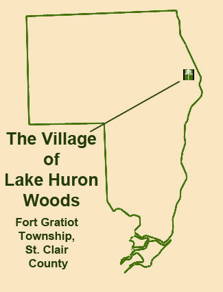
Fort Gratiot Township, Saint Clair County
42 Acres
Fort Gratiot Township, Saint Clair County
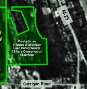
In 2019 through 2023, when Presbyterian Villages of Michigan planned and developed phase 2 of The Village of Lake Huron Woods in Fort Gratiot, they offered the Michigan Department of Environment, Great Lakes, and Energy a conservation easement on 42.36 acres of adjacent dune and swale forest as mitigation for 0.78 acre of State-regulated wetland impact on the 10.21-acre development preserve. While the conservation easement preserve is significantly larger than required, Presbyterian Villages of Michigan did not have development plans for the remainder of the site as buildable upland is very limited and wetland is extensive.
The wetland swales on the Lake Huron Woods conservation easement preserve consist of southern hardwood swamp on Tobico mucky fine sand dominated by Silver Maple (Acer saccharinum), Eastern Cottonwood (Populus deltoides), and Green Ash (Fraxinus pennsylvanica), however all the large Green Ash in the canopy are now dead due to the Emerald Ash Borer. Upland ridges are Wainola fine sand dominated by Silver Maple, Black Cherry (Prunus serotina), and American Basswood (Tilia americana). Paper Birch (Betula papyrifera) occurs along the bases of the sand ridges, indicating sandy upland with a seasonally high water table.
Based on plant surveys from 2002 through 2022, the Lake Huron Woods preserve has a Floristic Quality Index of 31.0, ranking as good floristic quality. Several plant species with moderately high coefficients of conservatism are indicative of the former mature forest community that once covered the area prior to logging, drainage, grazing, sand mining, and recent impacts. There are a few remaining Black Oak (Quercus velutina), Red Maple (Acer rubrum), Basswood, Yellow Birch (Betula alleghaniensis), Northern White-cedar (Thuja occidentalis), and Paper Birch scattered through the forest. The understory saplings are generally the same species composition as the canopy with scattered Hornbeam (Carpinus caroliniana) and Juneberry (Amelanchier arborea). The shrub layer is dominated largely by invasive Common Privet (Ligustrum vulgare), Multiflora Rose (Rosa multiflora), Japanese Barberry (Berberus thunbergii), and Tartarian Honeysuckle (Lonicera tatarica). While invasive Garlic Mustard (Alliaria petiolata) is extensive in some areas, the herb layer contains many important remnant plant species including Dwarf Raspberry (Rubus pubescens), Canada Mayflower (Maianthemum canadense), Round-leaved Pyrola (Pyrola americana), Red Trillium (Trillium erectum), Wild Sarsaparilla (Aralia nudicaulis), Blue Cohosh (Caulophyllum thalictroides), and Red Baneberry (Actaea rubra). A few regionally uncommon plant species, characteristic of the dune and swale complex include Purple-flowering Raspberry (Rubus odoratus), Yellow Lady’s-slipper orchid (Cypripedium parviflorum), Starry False Solomon-seal (Maianthemum stellatum), Northern White-cedar, Black Ash (Fraxinus nigra), Black Oak, Juneberry, and Alternate-leaved Dogwood (Cornus alternifolia).
Invasive plant species, including Common Privet, Tartarian Honeysuckle, and Multifloral Rose are widespread across the Lake Huron Woods preserve. Of these, Common Privet is dominant, likely comprising over half of the shrub layer and covering well over half the preserve. Garlic Mustard fills much of the upland herbaceous layer in some areas and may cover about 10% of the total preserve. Minor invasive species on the preserve include Japanese Barberry, Autumn-olive (Elaeagnus umbellata), Winged Wahoo (Euonymus alatus), and Reed (Phragmites australis subspecies australis). Despite the abundance of invasive weeds, good native forest species persist across much of the Lake Huron Woods preserve.
Historic use and impacts on the Lake Huron Woods preserve and vicinity have extensively degraded the natural landscape and native plant community, but essentially left it intact with very good potential for restoration and enhancement. From at least the late 1800s, both human-caused and natural degradation have affected the preserve, including:
Of these impacts, the draining of surface and ground water, followed by relatively recent reduction and fragmentation of the landscape has been most devastating. Continued degradation of the plant community includes invasive weeds and Emerald Ash Borer infestation. The loss of mature ash trees has reduced the forest canopy of the wetland swales to largely one species, Silver Maple. The elimination of mature ash trees has further degraded the plant community, reopening the forest canopy, decreasing shade, promoting the re-expansion of edge-forest and invasive species, and degrading woodland bird habitat. Invasive weeds are largely confined to the upland dune ridges and appear to have little direct impact on the wetland swales but overall degrade the native community.
Vegetation on the the Lake Huron Woods preserve prior to Euro-American settlement was likely cedar or Arbor Vitae and Tamarack swamp across most of the vicinity. What may have been the last Black Spruce (Picea mariana) in the county were recorded just south in adjacent Section 16 in the late 1800s by Port Huron botanist Charles K. Dodge. The largest dune ridges on the preserve were likely covered by narrow bands of Beech – Sugar Maple forest with oaks. The lowest swales likely consisted of some semi-open shrub swamp where inundation was extended. Since then, due to logging, drainage, clearing, possible grazing, and subsequent forest recovery, the vegetation has shifted to a complex of second-growth hardwood swamp and mesic upland forest. The shift probably began over a century ago upon the first logging event.
The Lake Huron Woods preserve is contiguous with the Thompson Drain, located roughly 300 feet north. The Thompson Drain was established around 1903 to provide drainage outlets to Lake Huron for agricultural lands to the west and may have also been an attempt to drain the wetland swales. As a result of the drain and the high porosity of the sand soils, there has likely been a significant reduction of the natural hydrology of the wetland swales on the preserve since the Thompson Drain was constructed. Many disturbances around the Lake Huron Woods preserve have likely altered the natural hydrology, but the Thompson Drain and the recent development of the Shorewood Forest subdivision have resulted in decreased continuity of swales on adjacent land and fragmentation of swales. The hydrology and plant community appear to have since stabilized, but significantly altered from the original condition prior to Euro-American settlement.
Livestock grazing in the early 1900s and the subsequent incursion of invasive weeds would have further degraded the remaining forest remnants while impeding forest recovery. As livestock generally don’t graze Common Privet, honeysuckle, and Multifloral Rose, it’s possible that this furthered the dominance of the shrubs. The 1937 aerial photograph shows much of the forest was absent from the upland beach ridges on the Lake Huron Woods preserve at that time.
Sand mining, beginning in the early 1900s, appears to have impacted the larger dune ridges on the west side of the Lake Huron Woods preserve. It’s possible that sand was also taken from some of the smaller ridges to the east and may be why some of the ridges are not quite as distinct as on other parts of this landscape.
Off-preserve reduction and fragmentation of the dune and swale landscape is the most detrimental and pervading threat to the preserve and the landscape as a whole. Natural buffer is lacking primarily to the south and east of the Lake Huron Woods preserve due to Carrigan Road and Lakeshore Drive and adjoining residential developments. To the north, the Shorewood Forrest subdivision has eliminated a large area of the dune and swale complex in the early 1990s, but a relatively wide natural buffer remains west of the development. To the west, the Lake Huron Woods preserve has perhaps some of the largest natural buffer that remains in Saint Clair County, primarily the Shorewood Forrest sanctuaries owned by the Thumb Land Conservancy. There are few areas that remain in the county, and especially in the Port Huron area, where there is a mile of uninterrupted forest. The Lake Huron Woods preserve is part of one of the largest woodlands remaining in the Port Huron area, being 1 mile north-south and nearly 1 mile east-west at the south end where there is little fragmentation except along M-25, Parker Road, and Carrigan Road. Except for county roads at 1-mile intervals and residences along each road, the forested dune and swale complex continues north for 2 miles relatively uninterrupted, and averages about a half mile wide.
Eastern White-tailed Deer were not particularly abundant in Saint Clair County until the early 1980s when their numbers began to rise sharply. So, just as native forest vegetation might have been recovering from previous impacts, it was then subjected to increased deer grazing which has risen steadily for almost 50 years. As a result, native forest wildflower populations have been severely reduced. Certain species like trillium have been all but eliminated in many woodlots. The Lake Huron Woods preserve would originally have supported an abundance of Red Trillium, but only a few have been observed in recent years.
Emerald Ash Borer has killed all the mature ash trees on the Lake Huron Woods preserve and throughout most of the region, the gradual die-off beginning in about 2006 to 2007. This has left large gaps in the forest canopy, encouraged the re-expansion of invasive herbs and shrubs, relegated ash trees to small saplings for the foreseeable future, and decreased the wetland forest canopy composition to mostly two species, Silver Maple and Eastern Cottonwood, leaving the forest vulnerable to severe degradation due to future diseases or pest infestations.
Current Land Use of the Lake Huron Woods preserve appears to be limited. Current or ongoing impacts to the preserve include mostly minor encroachments of adjoining landowners, continued overgrazing by Eastern White-tailed Deer, invasive plant species expansion, continued ash tree mortality due to the Emerald Ash Borer, and continued degradation of the plant and animal community due to decreased forest cover and lack of native forest species recruitment.
The Lake Huron Woods preserve is located within a Lake Huron direct drainage watershed. Wetlands on the preserve provide natural surface water detention, nutrient assimilation, sediment pollution treatment, and habitat for aquatic invertebrates, reptiles, amphibians, and aquatic and/or emergent vegetation. The preserve provides important undisturbed natural land within the coastal zone of Lake Huron. Protection of the preserve in its natural and open space condition helps to ensure the quality and quantity of water resources for the area
The Lake Huron Woods preserve is ecologically valuable because it is part of a larger forest extending along the Lake Huron coastline, providing critical habitat for migratory birds. A great variety of woodland birds have been observed on the preserve and across the landscape, especially many species of warblers. In addition, the preserve provides habitat for several regionally uncommon but unprotected species characteristic of the dune and swale complex. These include the Eastern Hog-nosed Snake, Blue-spotted Salamander, Purple-flowering Raspberry, Yellow Lady’s-slipper orchid, Northern White-cedar, Black Ash, Black Oak, and Starry False Solomon-seal.